Rafael Fire and Tiger Fire areas reduced closures
Big Idea
- Post-fire assessments on the Rafael and Tiger fire areas have been completed
- There are still restricted areas after both fires, but they have been reduced
- Anyone near and downstream from the burned areas should remain alert and stay updated on weather conditions
- Flash flooding may occur quickly
- Read more...
Post-Fire assessments have been re-evaluated
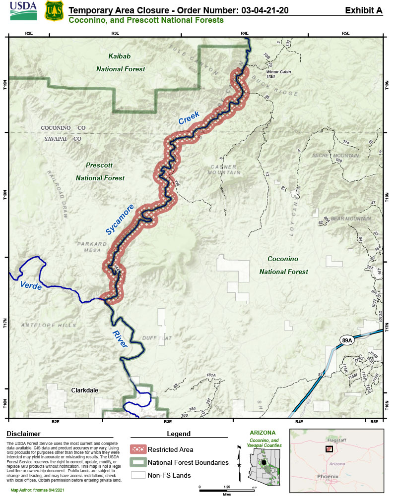
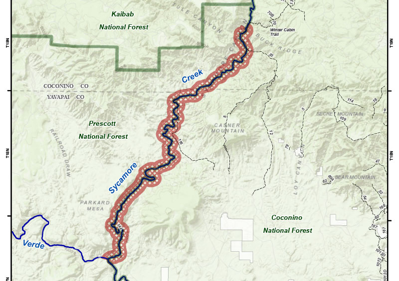
The Burned Area Emergency Response (BAER) Team has completed the post-fire assessment on the Rafael Fire, and Forest officials on the Coconino and Prescott National Forests have re-evaluated and reduced the Rafael Fire area closure.
The area restricted includes all National Forest System lands, roads, and trails within the boundary starting at the intersection of NFST #70 (Winter Cabin Trail) and the Sycamore Creek centerline, then continuing southwest along the centerline of Sycamore Creek extending ¼ mile out from the centerline on both sides of the creek, terminating at the confluence of Sycamore Creek and Verde River.
This order will be effective on August 6, 2021, at 12 p.m.
SPECIAL NOTE: Everyone near and downstream from the burned areas should remain alert and stay updated on weather conditions that may result in heavy rains over the burn scars. Flash flooding may occur quickly during heavy rain events--be prepared to take action. Current weather and emergency notifications can be found at the National Weather Service website.

Completed BAER Assessment Allows for Reduced Closure Area
PRESCOTT, AZ – August 4, 2021 - The BAER Team has completed the post-fire assessment on the Tiger Fire which is now 100% contained and have concluded the area affected by the fire does pose unacceptable post fire risks to public safety. High and moderate burn severity is associated with very steep slopes and escarpments which make these areas vulnerable to rockfall, subsequent downhill rock debris runout and soil instability. These hazards are expected to occur until after the summer monsoon events and freeze-thaw winter period that can initiate rockfall instability. Immediate post-fire flooding is also vulnerable within the fire footprint and to a limited downstream reach.
With the assessment complemented, Forest officials have re-evaluated and reduced the Tiger Fire area closure. Horsethief Basin Recreation Area is now open to the public; however, a large portion of the Castle Creek Wilderness remains closed.

Closure area description: The Restricted Area consists of all National Forest System lands, roads, and trails within the boundary starting at the intersection of the National Forest (NF) boundary and National Forest System Trail (“Trail”) 236, proceeding north along the east side of the trail for approximately 2.5 miles to its intersection with National Forest System Road (NFSR) 696, then following north along the east side of NFSR 696 for approximately one mile to its junction with Trail 31 and NFSR 52, then continuing north on the east side of NFSR 52 for approximately one mile to its junction with NFSR 697, then continuing north on the east side of NFSR 697 for approximately one mile, to its junction with Trail 240, then continuing north on the west side of Trail 240 for approximately one mile to its intersection with the southern border of Section 16 in Township 10N., Range 1E., then following the section line to the west approximately 0.5 miles to the southwest corner of Section 16, then continuing north one mile along the western border of Section 16, then, at the northwest corner of Section 16, continuing east three miles to the northeast corner of Section 14 in Township 10N., Range 1E., then continuing south one mile to the southeast corner of Section 14, then continuing east one mile to the intersection with the NF boundary, then continuing south along the NF boundary for 5 miles to the southeast corner of the NF boundary, then continuing west for approximately 2.5 miles to its intersection with Trail 236.
To view the Tiger Fire Closure and map, please visit our Alerts & Notices.
For information on the Prescott National Forest, check out the Prescott NF website and following us onFacebook and Twitter.
SPECIAL NOTE: Everyone near and downstream from the burned areas should remain alert and stay updated on weather conditions that may result in heavy rains over the burn scars. Flash flooding may occur quickly during heavy rain events--be prepared to take action. Current weather and emergency notifications can be found at the National Weather Service website.


