This is going to be a very cold week.
Big Idea
- Unsettled weather, thanks to a series of cold Pacific storms
- Rain and/or snow each day
- Did we mention it will be very, very cold?
- Get out your snowman-making gear!
- Read more...
It’s going to cold. Very cold.
Overview:
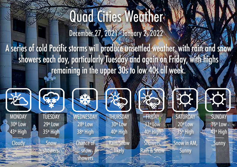
A series of cold Pacific storms will produce unsettled weather, with rain and snow showers each day, particularly Tuesday and again on Friday, with highs remaining in the upper 30s to low 40s all week.
Forecast Table:
https://www.wrh.noaa.gov/forecast/wxtables/
Navigate on the map to your location and click for a detailed local forecast.
Forecast:
Today, sunny and cold, with southwest winds gusting to 30 mph and highs in the 40s. Showers developing overnight and continuing through Tuesday, with snow down to about 4,500 ft and breezy southwest winds, with highs only in the upper 30s. Snowfall amounts will vary between 1-5 inches, depending on elevation. Wednesday and Thursday will continue mostly cloudy and cold with a chance of rain or snow showers each day and breezy winds from the south. Friday, rain showers, turning to snow overnight but tapering off. New Year’s Day will be mostly sunny but cold, with gusty northwest winds. Sunday morning will be very cold, with early morning temperatures dipping to the low to mid-teens and even into single digits in sheltered higher elevation locations.
Additional notes for the weather nuts:
Forecasting snow amounts when temperatures hover close to freezing is a challenging problem. Sometimes, snowflakes can reach the ground, even when temperatures are a few degrees above freezing due to an effect know as wet-bulbing. As precipitation falls to the ground, evaporation cools the air (and the precipitation particles) to the wet bulb temperature. This is the temperature recorded by a thermometer wrapped in a wet fabric – the so-called wet bulb thermometer – and is colder than the actual temperature. It is also the temperature of any wet surface on a windy day and the lowest temperature that your evaporative cooler can cool to in summer. The wet bulb temperature is roughly midway between the temperature and the dewpoint. At the start of a precipitation event when the air is still fairly dry, wet-bulbing can cause precipitation to start out as snow, even when temperatures are in the 40s. However, as evaporation adds moisture to the air, the dewpoint rises and the precipitation can change over to rain. Once the air becomes saturated, temperature, dewpoint and wet bulb temperature are equal.
Have a great week and may 2022 be brighter and happier than 2021.
Mark.
Mark Sinclair, Ph.D.
Program Chair and Professor, Meteorology
Department of Applied Aviation Sciences, College of Aviation
Met Mail is an unofficial weather discussion and forecast transmitted once or twice a week via e-mail by the Embry-Riddle Department of Meteorology (http://meteo.pr.erau.edu/). Embry-Riddle offers an undergraduate bachelor-of-science degree program in Applied Meteorology. Please spread the word to all potential qualified candidates!
Further Information:
ERAU Applied Meteorology degree program
Official National Weather Service forecast
Embry-Riddle Aeronautical University: Website | Facebook | Twitter | YouTube


