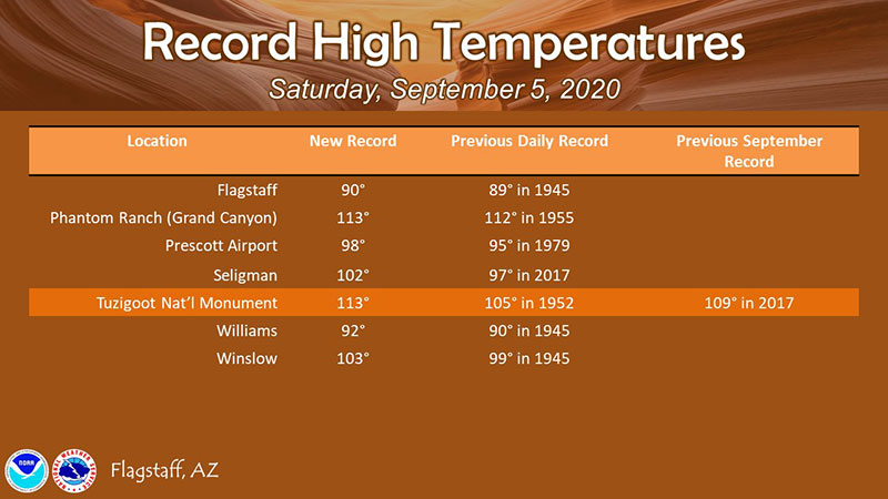
This weekend has brought record-breaking temperatures in Arizona, and that can be expected to continue through Labor Day.
Big Idea
- It’s hot, and it’s going to stay hot through Labor Day weekend
- Stay hydrated! Avoid heat-related health issues
- Tuesday starts a major cooling off
- Lows will be in the low 50’s next week
- Arizona’s favorite saying? "If you don’t like the weather, wait a few minutes and it might change.”
It’s HOT - but only for a couple more days.
So, how hot is it? Temperatures at Tuzigoot National Monument climbed to 113º on Saturday, shattering both the previous daily record and the previous record for all of September. Other communities, such as Flagstaff, Prescott, Seligman, Williams and Winslow all climbed over previous daily records to new highs. The heat will continue on Labor Day, so, stay hydrated, crank up the air conditioning one last time and watch cooking shows on tv. Or something.
Don’t forget, you are allowed to go swimming in some of the lakes now, if you choose! (Highly suggested: Wear water shoes that protect you from sharp objects!)
The crazy news is that by Tuesday, there should be a drastic cooling. In Prescott, the high will drop about 10 degrees, and overnight temps will be in the 50’s or lower. By Wednesday, the high should only be about 78º and lows in the 50’s. You may even want your heater on overnight! Here’s how the Weather Service describes Prescott’s weather:
Dangerous conditions due to heat exposure are likely in the lower elevations through Monday as very hot temperatures continue.
Starting Tuesday, an unseasonably strong weather system will deliver windy and cooler weather to northern Arizona,lasting through at least Thursday.
&&
.UPDATE...Many locations recorded new daily maximum high temperatures today as an unseasonably strong area of high pressure is bringing very hot temperatures to the Southwest. Very little changes with the evening update. Look for hot temperatures again tomorrow with some locations again likely to experience record breaking heat. ...Very hot weather will continue through the Labor Day weekend thanks to upper level high pressure centered over northern Arizona/southern Utah. This unseasonably strong high center will make little movement through the weekend keeping the warm air mass in place with record temperatures forecast each afternoon through Monday. Dangerous levels of heat will be experienced in the lower deserts where an Excessive Heat Warning will continue through Monday. These areas will see high temps reaching anywhere from 105 to 113 degrees. Anyone with outdoor plans should be prepared for heat and take appropriate precautions, especially avoiding activity during the heat of the day.
A drastic change in weather is forecast Tuesday/Wednesday of next week as a trough and strong cold front move southward through the Four Corners region. This autumn-like system will usher in gusty winds and a sharp drop in temperatures. Temperatures on Wednesday will be 20+ degrees cooler than what we`re experiencing this weekend. A chance for showers will accompany the frontal passage, but the latest model guidance is shifting toward the drier solution for Arizona. Expect cooler weather through Thursday, but temperatures look to quickly rebound behind this passing weather system.


